
Fire is recognised as a natural and essential requirement for the longterm health and viability of bushland and associated wildlife species in Ipswich. Managing fire in bushland areas is vital for the protection of surrounding homes, properties and structures and important in maintaining healthy, functioning ecosystems and habitats.
A key element of fire management is how both residents and council prepare and manage their bushland areas in order to mitigate risks and aid in ecosystem and habitat management. To achieve this, council and Ipswich residents must work together for the most effective approach - bushland fire management is very much a shared responsibility.
How does council manage bushland areas for fire?
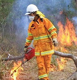
Council owns and manages more than 6,700 hectares of natural area estate across the city, including conservation/environmental estates, parks and reserves. Undertaking hazard reduction burns across the ten locations that make up Ipswich’s natural area estate is a key proactive management tool used to achieve balanced outcomes. Planned management activities are undertaken in a careful and proactive way to maintain the health of these areas and reduce the impact of wild fires. Activities include:
- Carrying out hazard reduction burns on designated sites to lower fuel loads, reduce fire intensity and maintain ecosystem health.
- Closing of natural areas on total fire-ban days and when fires are burning in surrounding landscapes.
- Implementation and maintenance of fire trails, signage and zones of protection.
- Removing and modifying vegetation through mechanical means such as slashing, manual removal, tree pruning and other methods.
Why undertake hazard reduction burns in natural area estates?
 A hazard reduction burn is used to:
- Reduce the amount of fire fuel in an area by slowly burning off undergrowth under controlled conditions.
- Assist in stimulating and promoting plants to regenerate and maintain healthy environmental conditions for the retention of ecosystems and biodiversity.
- Mitigate the risk of fire leaving or entering council-owned land (a legal responsibility as a land manager under the Queensland Fire Services Act 1995).
Bushfire risks for natural area estates
Council utilises mapping resources to identify areas that have a potential bushfire hazard across these reserves and estates. This is combined with other on-ground assessments to identify risk. This information is used to inform an overarching and streamlined strategic plan that addresses the way the natural area estate is to be managed for fire. High-risk areas are prioritised for hazard reduction burns or other treatments designed to reduce the amount or structure of fuel loads.
What areas does council plan to burn?
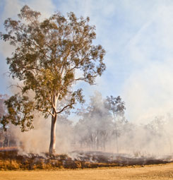
See information below regarding planned within Ipswich’s natural area estate. Estates or reserves (or parts of) subject to prescribed burns, are closed to the public immediately prior to, during and for a period of up to two weeks after the burn. These areas cannot be booked or used during this time and will be reopened, where applicable, when deemed to be safe for the public. The general public are advised to keep away from burn sites during this time in order to allow them to recover. During the prescribed burns, smoke may be visible from local streets and areas some distance from the sites.
Burn locations for 2024
The 2024 scheduled program of hazard reduction burns is being confirmed and will focus on priority areas within council conservation and bushland estates and reserves.
Please note that not all sites will be completed at the same time as they require different wind directions for the burn pattern and to avoid as much smoke as possible for residents and main roads. Council will endeavour to keep the burns as close as possible to limit the time conservation estates are closed.
How are hazard reduction burns managed?
Part of managing a hazard reduction burn includes collaborating with subject area experts.
Council works closely with Queensland Fire and Emergency Services (QFES) and the Rural Fire Service (RFS) in relation to joint planning initiatives, wildfire response and ongoing support for public fire awareness education.
Council also supports organisations such as the Queensland Fire and Biodiversity Consortium (QFBC), a regional working group partnering with a range of government and academic institutions to research and implement improved fire management practices.
Council takes a six-step approach to prescribed burns:
- Step 1 - Site prioritisation: high-priority burn sites are identified through a strategic approach considering a range of factors, including wildfire risk, fuel loads, fire history and fire containment infrastructure.
- Step 2 - Permit: a permit to light application is lodged with Rural Fire Services (RFS).
- Step 3 - Notification: the community is notified of hazard reduction burn plans a minimum of 72 hours in advance.
- Step 4 - Weather forecasts: weather is monitored to determine the most suitable day to implement the hazard reduction burn as per the permit.
- Step 5 - Estate/reserve closures: estates or reserves (or parts thereof) are closed and the hazard reduction burn is implemented.
- Step 6 - Completion: the hazard reduction burn is extinguished and cleaned up and the estate or reserve (or part thereof) is re-opened.
When does council plan to burn these sites?
Council proposes implementing hazard reduction burns primarily during the cooler months of April through to September.
This is generally when ground and weather conditions are most suitable for cooler, controlled burns.
This timeframe can be extended if favourable seasonal conditions allow.
The right combination of weather (speed and direction, relative humidity and temperature) and onground conditions will determine target dates.
Hazard reduction burns postponed due to unsuitable conditions will be rescheduled to a later date.
When and how does council announce burns?
- Depending when hazard reduction burns are implemented, notifications letters are generally sent out to individual residents within a 1km radius of a prescribed burn site two to four weeks prior to the scheduled burn date.
- Onsite signage notifying the public of scheduled hazard reduction burns.
- Council Facebook page and website are used to provide wider-reaching communication and list the current status of the burns and/or estate or reserve access.
- Media releases through local papers and/or public notices.
Preparing for hazard reduction burns in your local area

Living in or near bushland poses some level of risk from bushfire. The Queensland Fire and Emergency Services (QFES), as the lead agency responsible for informing the public about bushfire safety, has detailed information on their website on bushfire preparedness. All attempts will be made to limit any smoke, dust, stray ember and other hazards as works are undertaken.
Unfortunately, ideal weather conditions for conducting these hazard reduction burns can also mean that smoke is not always dispersed well. With this in mind, there are a number of steps you can take to prepare yourself and your property to reduce impacts:
- Keep doors and windows closed to prevent smoke entering your home.
- Remove washing from clothes line.
- Limit outdoor activities if smoke is a nuisance.
- If you suffer respiratory or other health conditions, keep medication close by, seek medical advice and reduce outdoor activities if smoke is present.
- Drive to conditions and use extra caution.
Residents adjoining prescrib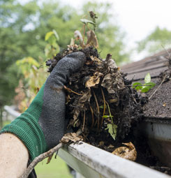 e burn sites should also:
- Ensure pets or livestock have a safe area to shelter.
- Place outdoor furniture undercover.
- Retract pool covers.
- Clear roofs, gutters and yards of flammable material such as leaves.
As a private landowner, residents are responsible for maintaining their own property safety and preparedness for fire. The level of fire management required will vary greatly depending on size and location of the property and types of vegetation present.
How does council minimise impacts on local wildlife?
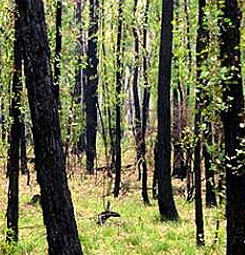
The direct effects of fire on wildlife are closely related to mobility. Birds and other flying animals can escape fire relatively easily, while some species avoid fires by leaving the area or by taking shelter under rocks, in waterways or hollow logs. The low intensity and inherent patchiness of prescribed burns provides wildlife with opportunities to escape into unburned areas or take shelter.
 The effects of fire on native fauna are not necessarily negative. Fire can impact animals indirectly through effects on vegetation and other habitat features. Nesting hollows can be created by fire. Reshooting vegetation provides ‘green pick’ for herbivores such as kangaroos, wallabies and insects. Increased levels of flowering and seeding follow fire as well as denser and more diverse vegetation as rejuvenated species compete for light and released nutrients. In locations not burned for long periods, aging vegetation may lose its productivity and some species may move elsewhere while plants which depend on fire to set seed may perish.
Council minimises impacts on wildlife during a hazard reduction burn in various ways:
- Leaving areas of bushland untouched for wildlife to use as a refuge and to help reestablish vegetation in burnt sections (patchiness).
- Excluding sensitive wildlife habitat from prescribed burns.
- Carrying out hazard reduction burns in cooler times, using slower and less intense burn activity with lower flames. This provides an opportunity for wildlife to move out of the area temporarily and escape to unburnt patches
- Inspecting sites prior to hazard reduction burns for wildlife and clearing around large fallen timber, hollow bearing trees and important habitat features.
More Information
- Queensland Fire and Rescue Service
- Queensland Health
- Department of Environment and Heritage Protection
- Ipswich City Council
- QLD Fire and Biodiversity Consortium
- Fire-related emergencies: Dial 000
For information regarding council’s hazard reduction burn program or associated estate or reserve closures call (07) 3810 6666 or email council@ipswich.qld.gov.au. For more information on council's conservation partnership program opportunities (including fire and property management planning) for bushland property owners email council@ipswich.qld.gov.au
Images courtesy of Queensland Fire and Biodiversity Consortium (photographers include G.Leah and C. Welden)