Bushland Fire Management
Managing fire in bushland areas is vital for the protection of surrounding homes, properties and structures and important in maintaining healthy, functioning ecosystems and habitats.
A key element of fire management is how both residents and council prepare and manage bushland areas in order to mitigate risks and provide ecosystem and habitat benefits. To achieve this, council and Ipswich residents must work together for the most effective approach - bushland fire management is very much a shared responsibility.
How does council manage bushland areas for fire?
Council owns and manages about 7,000 hectares of natural area estate across the city, including conservation/environmental estates, parks and reserves.
A variety of techniques are used to manage fire or reduce fire intensity and risk. Council's Enviroplan initiative funds proactive works such as:
- Carrying out hazard reduction burns (slow, cool burns) on designated sites to lower fuel loads, reduce fire intensity and maintain ecosystem health.
- Implementation and maintenance of fire trails, signage and zones of protection, to allow for access during burns.
- Removing and modifying vegetation through mechanical means such as slashing, manual removal, tree pruning and other methods.
- Closing public access during and after fire activity, for public safety and to allow natural regeneration.
Council uses mapping resources to identify areas that have a potential bushfire hazard across reserves and estates. This is combined with other on-ground assessments to identify risk. The information is used to inform an overarching and streamlined strategic plan that addresses the way the natural area estate is to be managed for fire. High-risk areas are prioritised for hazard reduction burns or other treatments designed to reduce the amount or structure of fuel loads.
Why undertake hazard reduction burns?
A hazard reduction burn is used to:
- Reduce the amount of fire fuel in an area by slowly burning off undergrowth under controlled conditions.
- Assist in stimulating and promoting plants to regenerate and maintain healthy environmental conditions for the retention of ecosystems and biodiversity.
- Mitigate the risk of fire leaving or entering council-owned land (a legal responsibility as a land manager under the Queensland Fire Services Act 1995).
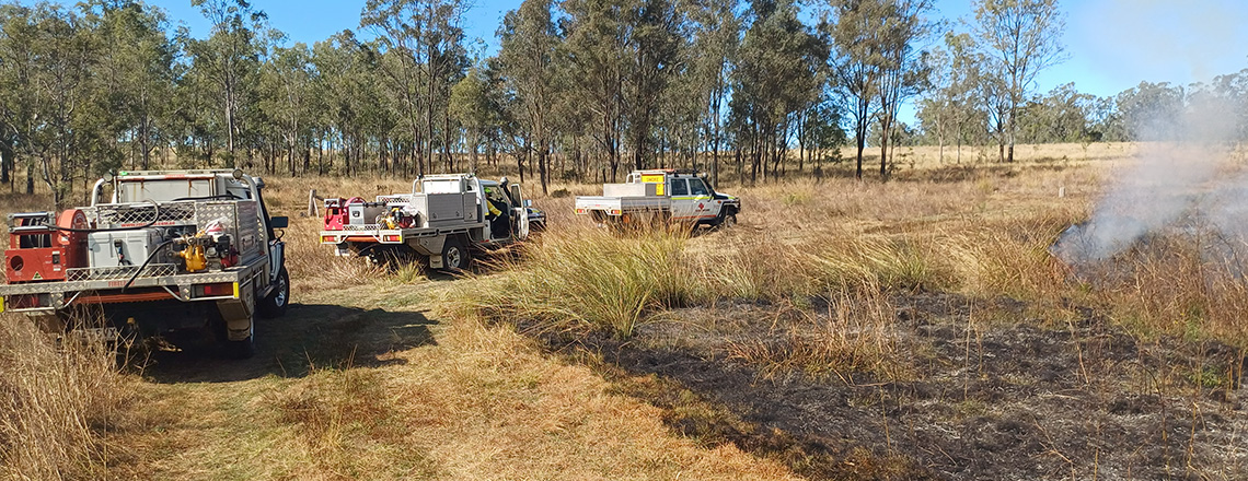
Hazard reduction burn
A low-intensity and controlled fire provides ecosystem and community safety benefits.
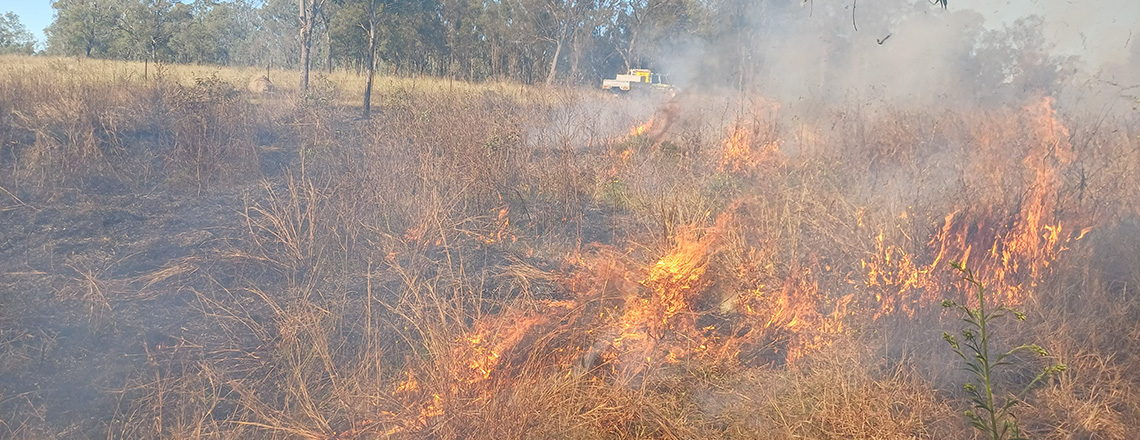
Hazard reduction burn
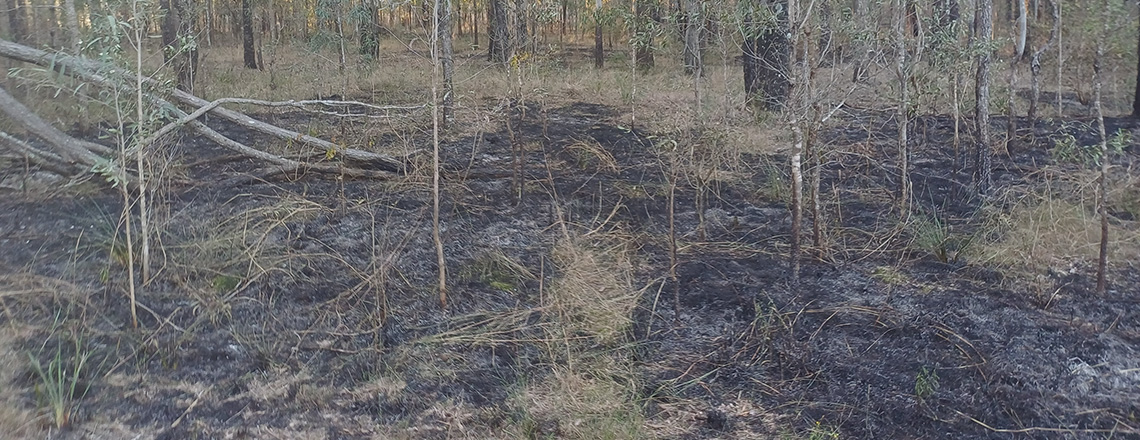
A 'mosaic' pattern of unburned patches helps wildlife escape the fire and assists regeneration.
Hazard reduction burn
A burn requires the right combination of ground and weather conditions. Smoke may persist in an area.
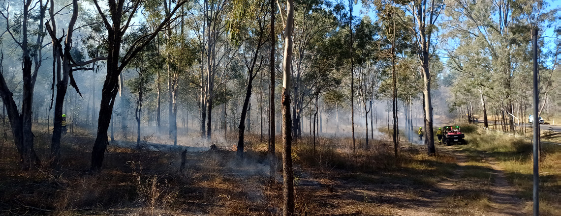
Hazard reduction burn
Burn sites are closely monitored before, during and after burn activity by experienced professionals.
What areas does council plan to burn?
See information below regarding planned within Ipswich’s natural area estate. Estates or reserves (or parts of) subject to hazard reduction burns, are closed to the public immediately prior to, during and for a period of up to two weeks after the burn. These areas cannot be booked or used during this time and will be reopened, where applicable, when deemed to be safe for the public. The general public are advised to keep away from burn sites during this time in order to allow them to recover. During the hazard reduction burns, smoke may be visible from local streets and areas some distance from the sites.
Potential burn locations for 2026
The 2026 scheduled program of hazard reduction burns focuses on priority areas within council conservation and bushland estates and reserves.
Please note that not all sites will be completed at the same time as they require different wind directions for the burn pattern and to avoid as much smoke as possible for residents and main roads. Council will endeavour to keep the burns as close as possible to limit the time conservation estates are closed.
| Estate |
Potential burn location |
Map ref |
Hectares |
Status |
| White Rock - Spring Mountain Conservation Estate |
Southern end of the estate in the vicinity of Stewartdale Nature Refuge, South Ripley |
WR9 |
200 |
Pending |
| In the vicinity of the Centenary Highway and Capilano Way, Spring Mountain |
WR15 |
35 |
Pending |
| In the vicinity of Aberdeen Circuit, Creekwood Circuit, Logging Crescent and Angelica Avenue, Spring Mountain |
WR16 |
20 |
Pending |
| In the vicinity of Cape Nelson Way, Yankari Lane and Wild Iris Terrace, Spring Mountain |
WR18 |
20 |
BURN ACTIVE Thursday 30 July 2026 |
| Flinders-Goolman Conservation Estate |
Southern end of the estate in the vicinity of Flinders Plum and Mount Flinders Road, Peak Crossing |
FG22 |
255 |
Pending |
| Mount Grandchester Conservation Estate |
In the vicinity of O'Brien Lane , Woolshed |
MG21 MG22 |
10 |
BURN ACTIVE Monday 27 July |
| South of O'Brien Lane, Woolshed |
MG12 |
45 |
Pending |
| Between Heise Road, Woolshed and Paidley Road, The Bluff |
MG6 |
45 |
Pending |
| Stirling Road Reserve |
In the vicinity of Stirling Road, Rosewood |
SR1 |
10 |
Pending |
How are hazard reduction burns managed?
Part of managing a hazard reduction burn includes collaborating with subject area experts.
Council works closely with Queensland Fire Department (QFD) and the Rural Fire Service (RFS) in relation to joint planning initiatives, wildfire response and ongoing support for public fire awareness education.
Council also supports organisations such as the Queensland Fire and Biodiversity Consortium (QFBC), a regional working group partnering with a range of government and academic institutions to research and implement improved fire management practices.
Council takes a six-step approach to prescribed burns:
- Step 1 - Site prioritisation: high-priority burn sites are identified through a strategic approach considering a range of factors, including wildfire risk, fuel loads, fire history and fire containment infrastructure.
- Step 2 - Permit: a permit to light application is lodged with Rural Fire Services (RFS).
- Step 3 - Notification: the community is notified of hazard reduction burn plans a minimum of 72 hours in advance.
- Step 4 - Weather forecasts: weather is monitored to determine the most suitable day to implement the hazard reduction burn as per the permit.
- Step 5 - Estate/reserve closures: estates or reserves (or parts thereof) are closed and the hazard reduction burn is implemented.
- Step 6 - Completion: the hazard reduction burn is extinguished and cleaned up and the estate or reserve (or part thereof) is re-opened.
When does council plan to burn these sites?
Hazard reduction burns are primarily done during the cooler months of April through to September. This is generally when ground and weather conditions are most suitable.
The right combination of weather (wind speed and direction, relative humidity and temperature) and on-ground conditions will determine target dates. Burn activity will be rescheduled if expected weather conditions change or become unsuitable.
When and how does council announce burns?
- This webpage is updated each season with information on priority sites.
- Notification letters are sent out to residents adjacent to a burn site to advise of the potential for burn activity.
- Onsite signage at the relevant estate/reserve notifies the public of scheduled hazard reduction burns.
- Council Facebook page is used to provide wider-reaching communication and the current status of the burns and/or estate or reserve access.
- General communication may also include media releases and/or public notices.
For information regarding council’s hazard reduction burn program or associated estate or reserve closures call (07) 3810 6666 or email council@ipswich.qld.gov.au
Preparing for hazard reduction burns at home
Living in or near bushland poses some level of risk from bushfire. All attempts will be made to limit any smoke, dust, stray ember and other hazards as works are undertaken. Unfortunately, ideal weather conditions for conducting these hazard reduction burns can also mean that smoke is not always dispersed well. With this in mind, there are a number of steps you can take to prepare yourself and your property to reduce impacts:
- Keep doors and windows closed to prevent smoke entering your home
- Remove washing from clothes line
- Limit outdoor activities if smoke is a nuisance
- If you suffer respiratory or other health conditions, keep medication close by, seek medical advice and reduce outdoor activities if smoke is present
- Drive to conditions and use extra caution.
Residents adjoining hazard reduction burn sites should also:
- Ensure pets or livestock have a safe area to shelter
- Place outdoor furniture undercover
- Retract pool covers
- Clear roofs, gutters and yards of flammable material such as leaves.
As a private landowner, residents are responsible for maintaining their own property safety and preparedness for fire. The level of fire management required will vary greatly depending on size and location of the property and types of vegetation present.
See more on the Queensland Fire Department website
How does council minimise impacts on local wildlife?
The direct effects of fire on wildlife are closely related to mobility. Birds and other flying animals can escape fire relatively easily, while some species avoid fires by leaving the area or by taking shelter under rocks, in waterways or hollow logs.
Hazard reduction burns are conducted to be low-intensity and leave a 'mosaic' pattern of unburned patches, which provides wildlife with opportunities to escape or take shelter. This includes
- Leaving areas of bushland untouched for wildlife to use as a refuge and to help re-establish vegetation in burnt sections (patchiness).
- Excluding sensitive wildlife habitat from burn activity.
- Carrying out hazard reduction burns in cooler times, using slower and less intense burn activity with lower flames.
- Inspecting sites prior to hazard reduction burns for wildlife and ensuring preservation of large fallen timber, hollow bearing trees and important habitat features.
Nature's response to fire
Some amazing changes can occur after an appropriate burn has happened in a natural area. Sunlight streams through the opened canopy and helps new growth. This provides 'green pick' for herbivores. Increased levels of flowering and seeding can follow fire, and re-sprouters such as eucalypts grow new shoots along the base of their blackened trunks. Obligate seeders like acacias grow from seed after fire, with some species releasing seed when exposed to smoke. Fire can also assist with the creation of tree hollows. In certain situations, fire can be a tool to reduce invasive weeds and give native species a chance to regenerate.
More information