Floods
Each year the City of Ipswich has the potential to experience flood in its various forms. While major floods have the most impact, localised flash floods from smaller creeks or overland flow paths can also be significant across the city.
Ipswich's subtropical climate makes it susceptible to weather that can cause flooding from rivers, creeks and overland flow. As such, floods usually occur across the summer months of December to March where the city typically receives half of its average annual rainfall (approximately 900mm).
While the city does experience tidal influences from Moreton Bay (extending to One Mile Bridge) these typically do not result in floods which have an impact to the community.

Image: Street scenes of the CBD during flood, Ipswich, 2011 (King Edward Parade). Picture Ipswich.
Types of floods
River flooding: Occurs when widespread and prolonged rain falls over the catchment area of a river. Severe weather, such as from ex-tropical cyclones, are often the trigger. Typically, flood water overtops and spreads across the floodplain on one or both banks of a river. A river flood often takes more than six hours after rain has fallen before it begins to impact the city and can take days to recede.
Creek flooding: Creek flooding is similar to river flooding but is more driven by localised rain events within creek catchments. Creek flooding will typically have a rapid rise of water levels, typically less than six hours following rain, resulting in limited warning time for emergency procedures.
Overland flow (stormwater) flooding: Flooding from excess rainfall runoff which exceed the capacity of underlying soils or drainage networks. It flows across land before entering a creek or river. Overland flow flooding affects a large proportion of existing urban areas across the city.
How council manages floods
As a city on a floodplain, flooding will remain a natural risk to the Ipswich community. Council manages the risk via the following measures:
Floodplain Management Strategy: Council's Floodplain Management Strategy outlines the city's approach to floodplain management (also referred to as flood risk management). This strategy communicates the city's vision and goals in relation to floodplain management.
Flood Studies: Council maintains flood knowledge through an annual program which prioritises and updates the city's repository of flood studies (Bremer River and area catchments). Council's Flood Studies webpage contains the latest study reports and Council specific technical guidance (eg. Australian Rainfall & Runoff).
Brisbane River Catchment Flood Studies: The Queensland Floods Commission of Inquiry, following the 2011 floods, recommended the creation of a regionally consistent flood study and strategic management plan of the lower Brisbane River catchment, which includes the local government areas of Somerset, Lockyer Valley, Ipswich and Brisbane.
The Brisbane River Catchment Flood Studies (BRCFS) as it is known, is a project led by the Queensland Government in collaboration with the four (4) local government authorities. The BRCFS is periodically updated by the Queensland government and has two main components:
Further information and educational materials can be found on the Queensland Reconstruction Authority website. This includes overviews, videos and factsheets relevant to the community.
Local Floodplain Management Plan: In response to the BRCFS, each local government area prepared their own local floodplain management plan. Ipswich's local floodplain management plan is the Ipswich Integrated Catchment Plan.
Planning Scheme: Ipswich's City Plan is the primary land use planning tool for managing development of the city's floodplains by balancing appropriate development with sustainable use of the floodplains by balancing appropriate development with sustainable use of the floodplain. Council's City Plan was adopted on 1st July 2025 and includes a comprehensive flood risk overlay to guide development in these areas.
The Planning Scheme is continuously updated to meet changing policy, new flood information, technology and best practice.
Disaster Management: Council's Disaster Management webpage provides information on natural hazards which includes how the community can 'Be Flood Ready'. Council's primary guide on disaster management is the Local Disaster Management Plan. Information is available in multiple languages.

Rain and river gauge network: Council maintains a network of rain and river level monitoring gauges across the city which provide continuous records and intelligence during flood events. Other organisations such as the Bureau of Meteorology, Seqwater, and the Queensland Government also operate gauges within the Ipswich local government area.
The most obvious sign of a monitoring gauge is a tower which looks like the photo shown. Vandalism is unfortunately a common issue and if is observed, please report the incident to Ipswich City Council (3810 6666) or Police Link (131 444).
Flood mitigation and stormwater upgrades: Council undertakes mitigation and stormwater network upgrades from time to time either as new capital works or as part of rehabilitation and improvement projects. Some notable mitigation measures to date include:
- Dry detention basins at Marburg, Rosewood, Ipswich CBD and the lower and higher Springfield Lakes. Due to the size of these structures, these have been categorised as 'referable dams' with associated Emergency Action Plans.
- Thagoona township flood levee along Karrabin-Rosewood Road.
- Redbank Plains Recreation Reserve detention basin.
Historical flood information
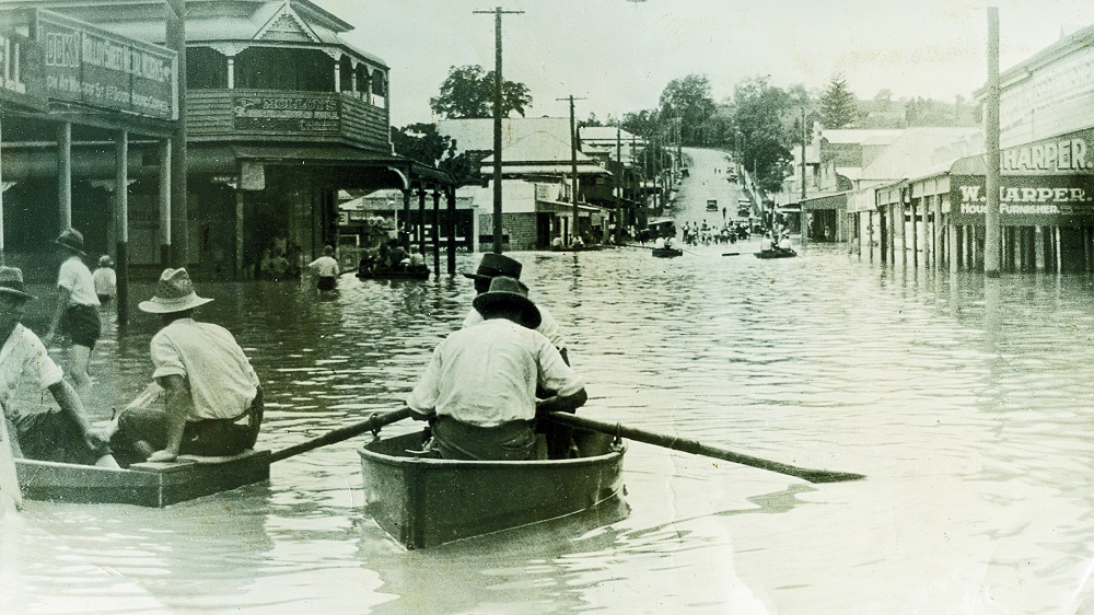
Image: Brisbane Street in flood, Ipswich 1927. Picture Ipswich
Historical flood maps for the 1974, 2011 and 2022 flood events are available from Council's Planning and Development site.
Picture Ipswich has a repository of historical photographs available online, including historical images of floods.
Ipswich Libraries has a wide range of books, newspaper articles and documents available in the general collection or within the Local History Room.
The Bureau of Meteorology also keeps detailed reports on flood events that have affected Queensland. These include major events such as 1893, 1974, 2011, 2013 and 2022 as well as various smaller flood events that may not have been as widely reported.
The community are encouraged to submit flood information for historical records to council@ipswich.qld.gov.au, especially following an event. However, it is recommended that information such as photos include reference points to help identify location and levels if possible.