
Catchment management is an approach to planning and managing our local waterways and environment for the long term sustainability of our natural resources.
It involves everyone - residents, industry, organisations, schools, government and council - contributing and working together to improve our local environment.
About our catchments
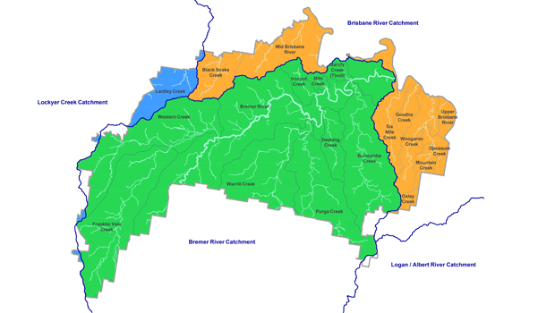 The majority of the Ipswich local government area lies within the lower Bremer River catchment. The Bremer River catchment covers a total area of 2028km2 and also flows through Scenic Rim local government area. Further information can be viewed in:
The Brisbane River forms Ipswich's north eastern boundary. The north-western part of Ipswich falls in the Mid Brisbane River catchment, which is the primary drinking water catchment for South-East Queensland. Further information can be viewed in
Eastern suburbs of Ipswich are included in the highly urban Lower Brisbane River catchment. More information can be viewed in the Lower Brisbane River Catchment Story.
A small portion of Lockyer Creek catchment also crosses into Ipswich in the Woolshed area.
Read more in the Waterway Health Strategy
How you can help
Community engagement and participation are essential to catchment management. There are many ways that the Ipswich community can participate and support catchment health and resilience.
There are opportunities to volunteer and support the restoration of riparian corridors with activities such as weeding and planting. Some Bushcare groups specifically target creek and river areas with regular working bees. Council's Habitat Connections program also provides opportunities for community tree plantings along important riparian areas. There are also local groups, such as Bremer Catchment Association, which are committed to catchment management activities.
Landholders also have a vital role in catchment management. Activities on private property have an impact on the rest of the catchment. Council has a number of programs to support landholders to take appropriate action to minimise detrimental effects. This includes the Landholder Conservation Partnerships Program, as well as catchment-based initiatives such as the Franklin Vale Initiative and Resilient Rivers works at Black Snake Creek.
Ipswich City Council respectfully acknowledges the Traditional Owners, the Jagera, Yuggera and Ugarapul people of the Yugara/Yagara Language Group, as custodians of the land and waters we share. We pay our respects to their Elders past, present and emerging, as the keepers of the traditions, customs, cultures and stories of proud peoples.