
Each year the City of Ipswich has the potential to experience flood in its various forms. While major floods have the most impact, localised flash floods from smaller creeks or overland flow paths can also be significant across the city.
Ipswich's subtropical climate makes it susceptible to weather that can cause flooding from rivers, creeks and overland flow. As such, floods usually occur across the summer months of December to March where the city typically receives half of its average annual rainfall (900mm).
While the city does experience tidal influences from Moreton Bay (extending to One Mile Bridge) these typically do not result in floods which have an impact to the community.
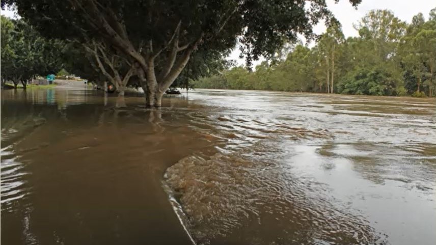 Image: Street scenes of the CBD during flood, Ipswich, 2011 (King Edward Parade). Picture Ipswich.
Types of floods
River flooding: Occurs when widespread and prolonged rain falls over the catchment area of a river. Severe weather, such as from ex-tropical cyclones, are often the trigger of this type of flood. Typically, flood water overtops the river bank and spreads across the floodplain on one or both banks of a river. A river flood often takes more than six hours after rain has fallen before it begins to impact the city and can take several days to fully recede.
Creek flooding: While the mechanisms are similar to river flooding, creek flooding can also occur as the result of smaller and more localised rain events within the catchment area of a creek. Creek flooding from local rain events will typically have a rapid rise and fall of water levels. Flooding typically occurs less than six hours following rain, resulting in limited warning time for emergency procedures.
Overland flow (stormwater) flooding: Excess rainfall runoff beyond the capacity of underlying soils or underground drainage network. It flows across the land before entering a creek or waterway. Overland flow flooding affects a large proportion of areas across the city.
How council manages floods
As a city located on a floodplain, flooding will remain a natural risk to the Ipswich community. Council has a range of measures to reduce the impacts of floods on the city and community.
Floodplain Management Strategy: Council's Floodplain Management Strategy outlines the city's approach to floodplain management (also referred to as flood risk management). This strategy communicates the city's vision and goals in relation to floodplain management. It also outlines how council responds to floodplain management in order to ensure our city remains safe, liveable and resilient.
Brisbane River Catchment Flood Studies: A key recommendation from the Queensland Floods Commission of Inquiry was the creation of a regionally consistent flood study and strategic management plan of the lower Brisbane River catchment, which includes the local government areas of Somerset, Lockyer Valley, Ipswich and Brisbane.
The regional study and strategic plan are referred to as the Brisbane River Catchment Flood Studies. This collaborative project was led by the Queensland Government together with the local government authorities. The three main components are:
- The Brisbane River Catchment Flood Study reports and models
- A regional Brisbane River Strategic Floodplain Management Plan
- Local Floodplain Management Plans - locally the document is called the Ipswich Integrated Catchment Plan
Further information and educational materials can be found on the Queensland Reconstruction Authority website. This includes overviews, videos and factsheets relevant to the community.
Planning Scheme: The Ipswich City Plan 2025 is the primary land use planning tool for managing development of the city's floodplains. The City Plan aims to balance appropriate development with sustainable use of the floodplain.
Emergency Management: Council's Emergency Management webpage provides information on disasters which includes how the community can 'Be Flood Ready'. Council's primary guide on emergency management is the Local Disaster Management Plan. Information is available in multiple languages.
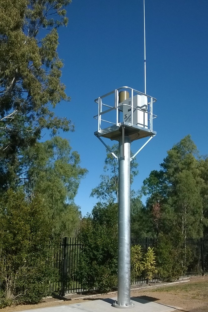 Rain and river gauge network: Council maintains a network of rainfall and river level monitoring gauges across the city. These gauges provide a continuous record and valuable intelligence during periods of rainfall and flood events. Other organisations such as the Bureau of Meteorology, Seqwater, and the Queensland Government also operate gauges within Ipswich's local government area. Data from these gauges are shared with the Bureau of Meteorology.
The most obvious sign of a monitoring gauge is a tower containing the monitoring and recording instruments. Unfortunately vandalism does occur, and some gauges are in remote areas. If vandalism is observed on a monitoring gauge please report it to Ipswich City Council (3810 6666) or Police Link (131 444).
Flood mitigation and stormwater: Council has undertaken a number of flood mitigation projects to reduce risks to the existing community. Recent projects include:
- Culvert upgrades
- Localised stormwater drainage improvements
- Dry detention basins at Marburg, and Rosewood and Ipswich CBD, classified as 'referable dams'. These are maintained to a high level of safety standard with their own Emergency Action Plans
Flood studies
Council's flood study program continually prioritises and updates the city's repository of flood models (both river and creek scale) to maintain a current understanding of flood behaviour.
To date, the following Council flood study reports are available below. More reports will be made available over time. Being technical documents, assistance from a qualified professional should be obtained if necessary.
Please contact council@ipswich.qld.gov.au for further information.
Please note: Flood study models are only provided to professionals to facilitate development applications which require hydraulic impact assessments. A service fee is necessary to access the models.
REGIONAL:
Ipswich Rivers Flood Studies Update
The Ipswich Rivers Flood Studies Update models the Bremer River catchment from Moogerah Dam to the Brisbane River confluence.
- Milestone 4: Technical Summary - Report (PDF, 10.6MB)
- Milestone 3: Design Flood Modelling and Mapping - Report (PDF, 6.4MB)
- Milestone 3: Design Flood Modelling and Mapping - Results Addendum Part 1 (PDF, 41.3MB)
- Milestone 3: Design Flood Modelling and Mapping - Results Addendum Part 2 (PDF, 39MB)
- Milestone 3: Design Flood Modelling and Mapping - Results Addendum Part 3 (PDF, 38.1)
- Milestone 2: Model Development and Calibration - Report (PDF, 14.4MB)
- Milestone 2: Model Development and Calibration - Results Addendum (PDF, 34.9MB)
- Milestone 1: Data Collection and Review - Report (PDF, 4.3MB)
- Milestone 1: Data Collection and Review - Site Inspection Addendum (PDF, 5.1MB)
BREMER RIVER CREEKS:
Bundamba Creek Flood Study
Deebing Creek Flood Study
MiHi Creek Flood Study
Newtown area Flood Study
- Newtown Area Flood Study 2024 - Main Report (PDF, 19.3MB)
- Newtown Area Flood Study 2024 - Appendix A to C (PDF, 43.5MB)
- Newtown Area Flood Study 2024 - Appendix D to F (PDF, 34.5MB)
- Newtown Area Flood Study 2024 - Appendix G (PDF, 49.7MB)
- Newtown Area Flood Study 2024 - Appendix H (PDF, 49.2MB)
- Newtown Area Flood Study 2024 - Appendix I (PDF, 49.2MB)
- Newtown Area Flood Study 2024 - Appendix J (PDF, 49.1MB)
- Newtown Area Flood Study 2024 - Appendix K to L (PDF, 49.9MB)
Rosewood area Flood Study
Thagoona area Flood Study
Walloon area Flood Study
- Walloon area Flood Study - Main Report - Volume 1 of 2 (PDF, 14.92 MB)
- Walloon area Flood Study - Main Report - Volume 2 of 2 (PDF, 30.10 MB)
- Walloon area Flood Study - Hydraulic Risk & Scenario report Part 1 (PDF, 36.16 MB)
- Walloon area Flood Study - Hydraulic Risk & Scenario report Part 2 (PDF, 19.22 MB)
BRISBANE RIVER CREEKS:
Goodna Creek Flood Study
Sandy Creek Camira Flood Study
- Sandy Creek Camira Flood Study 2024 - Main Report (PDF, 3.5MB)
- Sandy Creek Camira Flood Study 2024 - Appendix A to B (PDF, 2.3MB)
- Sandy Creek Camira Flood Study 2024 - Appendix C (C-1) (PDF, 39.5MB)
- Sandy Creek Camira Flood Study 2024 - Appendix C (C-2) (PDF, 38.2MB)
- Sandy Creek Camira Flood Study 2024 - Appendix C (C-3) (PDF, 38MB)
- Sandy Creek Camira Flood Study 2024 - Appendix C (C-4) (PDF, 37,7MB)
- Sandy Creek Camira Flood Study 2024 - Appendix C (C-5) (PDF, 39MB)
- Sandy Creek Camira Flood Study 2024 - Appendix C (C-6) (PDF, 37.9MB)
- Sandy Creek Camira Flood Study 2024 - Appendix D (PDF, 40,5MB)
Six Mile Creek Flood Study
Tallegalla and Woolshed Area Flood Study
Historical flood information
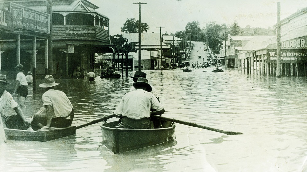 Image: Brisbane Street in flood, Ipswich 1927. Picture Ipswich
Historical flood maps for the 1974, 2011 and 2022 flood events are available from Council's Planning and Development site.
Picture Ipswich has a repository of historical photographs available online, including historical images of floods.
Ipswich Libraries has a wide range of books, newspaper articles and documents available in the general collection or within the Local History Room.
The Bureau of Meteorology also keeps detailed reports on flood events that have affected Queensland. These include major events such as 1893, 1974, 2011, 2013 and 2022 as well as various smaller flood events that may not have been as widely reported.
The community are encouraged to submit flood information for historical records to council@ipswich.qld.gov.au, especially following an event. However, it is recommended that information such as photos include reference points to help identify location and levels if possible.
Ipswich City Council respectfully acknowledges the Traditional Owners, the Jagera, Yuggera and Ugarapul people of the Yugara/Yagara Language Group, as custodians of the land and waters we share. We pay our respects to their Elders past, present and emerging, as the keepers of the traditions, customs, cultures and stories of proud peoples.